Do you ever get advertisements on your mobile device as you pass a McDonald's or Tim Hortons? What about mail that people in other neighbourhoods don't get, or email and social media ads for things that seem to target you directly? These are all examples of 'spatial targeting', which helps advertisers send messages to the most relevant recipients.
Public health and injury prevention experts can do the same thing. Targeting the right people in the right places is especially important in this field, which often has minimal financial resources to share important messaging that can save lives.
This is where Geographical Information Systems (GIS) Application Specialists come in!
The Role of a GIS Application Specialist
Over the last 12 years, Fanshawe Professor Andrew Clark has worked with various organizations to help them geospatially target the best locations to run their projects. Using his expertise as a GIS Application Specialist, Andrew helps health promoters and injury prevention specialists maximize their budgets, geospatially targeting locations where the people who should see their advertisements tend to live, work and play.
One of these projects included the Buckle Up, Phones Down campaign from Middlesex-London Health Unit.
Case Study: How Buckle Up, Phones Down Used GIS to Target the Right Audience
The campaign focused on personal stories and consequences of distracted driving to change attitudes and behaviours among youth in the London-Middlesex region. It included education components such as social media ads, a movie theatre trailer, a high school student video contest, billboards and transit shelter ads as well as police enforcement.
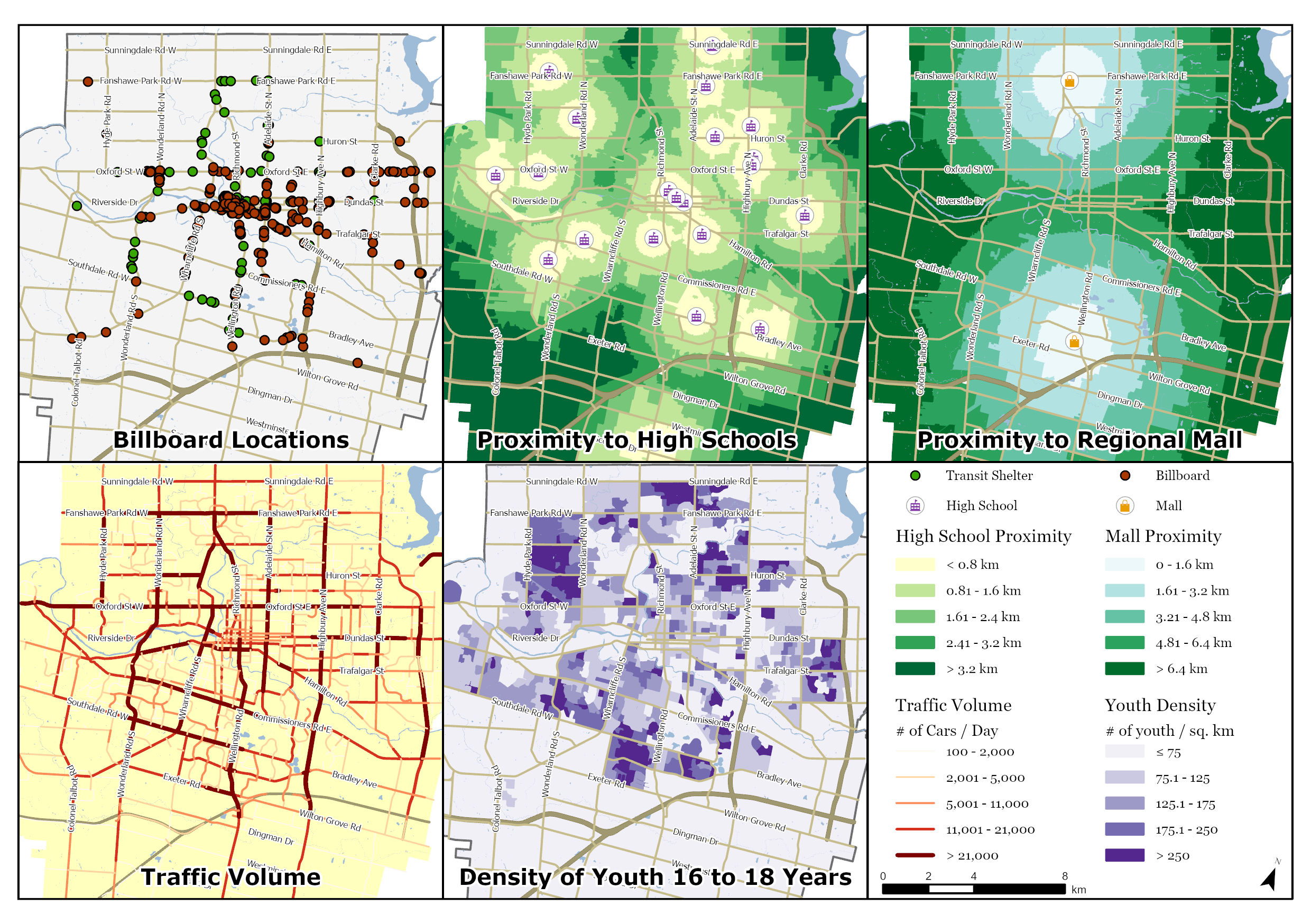
As a GIS Application Specialist and the spatial analyst on the project, Andrew's job was to geospatially target places where London-Middlesex youth (1) would most likely see billboard and bus shelter ads, and (2) were most likely to use a mobile device while driving. His research involved literature reviews, surveys, and interviews with experts to determine the most important criteria to analyze. He then used GIS calculations to create a series of maps and identify optimal billboards and bus shelters for educational messaging and nearby roads where a police enforcement blitz could occur.
The educational campaign was very successful, with 71% of residents seeing or hearing about it and over 400 people recognizing the "Buckle Up, Phones Down" campaign.
GIS analysts and specialists like Andrew play an important role in public health and injury prevention work, using data to maximize return on investment by targeting locations where the right people will be most likely to see important or even life-saving messages.
You can learn more about using GIS in public health with Fanshawe's micro-credential series, GIS & Public Health, which includes instruction on Andrew's methodology in a course called Multicriteria Decision Making in GIS.
Other full-time programs offered in the School of Design in GIS include:
Bachelor of Environmental Design & Planning
GIS Post-Graduate Certificate Program
Acknowledgements: Professor Andrew Clark and the School of Design at Fanshawe College would like to thank members of the London-Middlesex Road Safety Committee for their work on the "Buckle Up, Phones Down" project as well as the collaborators on the program evaluation including Professor Jason Gilliland (PhD) from Western University's Human Environments Analysis Laboratory and Epidemiologist Tanya Charyk-Stewart from London Health Sciences Centre's Trauma Program. Without their leadership, this injury prevention program would not have happened. A full write-up of the project can be found in the Journal of Trauma & Acute Care Surgery.
Submitted by: Andrew Clark, PhD
Professor, GIS & Urban Planning
Professor, Environmental Design & Planning
School of Design, Fanshawe College


